
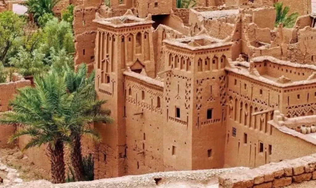
The map of Morocco tells a story that surprises almost every first-time visitor. In a single country, only a little larger than the US state of California, you find snow-capped mountains, Atlantic surf beaches, walled medieval cities, and the golden dunes of the Sahara.
Learning to read that map is the difference between a rushed, exhausting trip and a smooth, well-paced one. At AFC Morocco Travel, we have planned routes across this country from our base in Tinghir, in the heart of the Draa-Tafilalet region, for over thirty years.
We have built this guide to show you exactly how Morocco fits together. If you would rather skip the planning and travel with people who know every pass and piste by name, browse our guided Morocco tours, and we will map the whole journey for you.
This guide walks you through where Morocco sits on the world map, its six main travel regions, all twelve airports, the major cities, and the real driving distances that connect them.
Spanish speakers searching for a mapa de Marruecos” and French speakers looking for a “carte du Maroc” will find the same regions and routes described here, since this is the country known internationally as Morocco, Marruecos, and Maroc.
Where Is Morocco on the Map?
Morocco sits in the far northwestern corner of Africa, in the region known as the Maghreb. Find it on a world map, and you will see it directly below Spain, separated from Europe by only 14 kilometers of water at the Strait of Gibraltar. That short gap makes Morocco the closest African country to Europe, near enough that on a clear day, you can see the Spanish coastline from the hills above Tangier.
Looking at Morocco on a map of Africa, the country anchors the top-left corner of the continent. It shares a land border with Algeria to the east and southeast and with Western Sahara to the south. Two small Spanish enclaves, Ceuta and Melilla, sit on its Mediterranean coast. The Atlantic Ocean runs the full length of the western edge, while a shorter Mediterranean coastline of roughly 200 kilometers stretches from Tangier toward the Algerian border. A map of Morocco and Spain shows just how tightly Europe and Africa meet at this point.
A few facts help you place the country in context:
- Size: Morocco covers 710,850 square kilometres, which makes it larger than France and slightly bigger than Texas.
- Capital city: The capital is Rabat, not Casablanca. This catches many travellers out. Casablanca is the largest city and the economic hub, but Rabat is the political capital you will see marked on any official map.
- Time zone: Morocco runs on GMT+1, the same as much of Western Europe, so visitors from the UK, Ireland, France, and Spain face little or no jet lag.
- Coordinates: The country sits at roughly 31 degrees North and 7 degrees West.
Whether you are looking at a political map of Morocco, a simple outline map, or Morocco on a map of the world, the country plays the same role: a gateway between Europe, the Atlantic, and the vast Sahara that opens up to the south.
Physical Map of Morocco: Mountains, Valleys and Desert
The physical map of Morocco divides neatly into three bands: mountains running down the middle, fertile plains along the coast, and desert to the south and east. Once you understand these three bands, the rest of the country makes sense, including why a journey of 300 kilometres can take five hours and why the scenery changes so completely from one day to the next.
The Mountain Ranges
Four ranges shape the country. The High Atlas runs diagonally across the centre and holds Jebel Toubkal, which at 4,167 metres is the highest peak in all of North Africa. The Middle Atlas lies to the north, with cedar forests and quiet mountain lakes. The Anti-Atlas marks the dry transition toward the Sahara. In the far north, the Rif Mountains rise straight up from the Mediterranean and create their own green, misty microclimate. Any Atlas Mountains map of Morocco will show these ranges acting as a natural spine that separates the wet coast from the dry interior.
The mountains matter for one very practical reason: the passes. The Tizi n’Tichka pass, at 2,260 meters, carries the main road from Marrakech to Ouarzazate and the desert beyond. It can close for short spells in winter when snow falls. The Tizi n’Test pass, at 2,093 meters, offers a slower and more dramatic alternative route to the south.
The Valleys and Gorges
South of the High Atlas, the land folds into deep valleys and gorges, and this is the part of Morocco we know best. The Todra Gorge, a short drive from our base in Tinghir, cuts a canyon 300 metres deep that narrows to just 10 metres wide at the bottom. The Dades Gorge winds through curving rock formations that locals call the monkey fingers. The Draa Valley holds the longest palm grove in the country, running for around 150 kilometers as it heads toward the desert.
The Desert
Two great dune fields define the Moroccan Sahara on the map. Erg Chebbi, near Merzouga, rises to around 150 meters and is the more accessible of the two. Erg Chigaga, near M’Hamid, is wilder, harder to reach, and far quieter, which is why we favour it for travellers who want true silence. A Sahara Desert Morocco map shows these two ergs as the main gateways into the dunes, each reached by a different route across the south.

Morocco Regions Map: The Six Major Travel Zones
Northern Morocco: Mediterranean Coast and Rif Mountains
The north feels different from the rest of the country, shaped by the Mediterranean and a strong Spanish influence. The blue-washed town of Chefchaouen draws the most visitors, tucked high into the Rif Mountains. Tangier guards the Strait of Gibraltar and has reinvented itself as a stylish coastal city, while Tetouan holds a UNESCO-listed medina. For this region, you fly into Tangier (TNG). From Fez, the drive up to Chefchaouen takes around two hours. A map of northern Morocco shows just how close this corner sits to Europe.
The Atlantic Coast: Casablanca to Agadir
Morocco’s Atlantic edge runs for nearly 3,000 kilometres and holds the country’s largest cities. Casablanca is the commercial capital and home to the vast Hassan II Mosque, which rises right at the water’s edge. Rabat, the national capital, sits a short drive to the north. South of Casablanca, the fortified port of Essaouira is a long-time favorite for its relaxed pace and steady Atlantic wind, and Agadir offers modern beach resorts and reliable sunshine. From Marrakech, Essaouira is about two and a half hours by road.
The Imperial Cities: Central Morocco
Four cities have served as Morocco’s capital through history, and together they form the classic cultural circuit: Fez, Meknes, Marrakech, and Rabat. Fez holds the oldest and largest living medieval medina in the world, a maze of thousands of alleyways where you can still watch leather being tanned by hand. Marrakech, sitting at the foot of the Atlas, is the country’s tourism heart, built around the famous Jemaa el-Fnaa square. Near Meknes lie the well-preserved Roman ruins of Volubilis. A Marrakech map of Morocco and a Fez map both place these cities in the fertile heartland, and the full circuit covers roughly 700 kilometres.
The High Atlas and Anti-Atlas Mountains
This is hiking, kasbah, and Berber village country. Ait Benhaddou, a fortified earthen village used as a backdrop in Gladiator and Game of Thrones, is the star attraction and a UNESCO World Heritage site. Ouarzazate, often called the gateway to the desert, has its own working film studios. Imlil, an hour from Marrakech, is the launch point for treks up Toubkal. Almost all roads into the Atlas begin in Marrakech, which makes the city the natural base for mountain travel.
Draa-Tafilalet: The Kasbah Trail and Desert Gateway
This is our home region, and the section of the map we know better than any other. Draa-Tafilalet runs along the southern slope of the Atlas and holds some of Morocco’s most dramatic scenery: the Todra and Dades gorges, the Draa Valley palm groves, and a long string of ancient fortified villages known as ksour. Tinghir sits at the heart of it, with Todra Gorge on its doorstep. Ouarzazate airport (OZZ) is the nearest, around 70 kilometres away. From Marrakech, the drive to Tinghir takes about five and a half hours along the N9 and N10, the road that travellers know as the Kasbah Trail. If you want to explore this region with guides who actually live here, this is exactly the journey we have built our reputation on.
The Sahara Desert: Erg Chebbi and Erg Chigaga
The desert is the reason many people come to Morocco in the first place, and the map shows two main gateways. Merzouga gives access to the Erg Chebbi dunes and works well as part of a loop from Fez or Marrakech. M’Hamid opens onto the remote Erg Chigaga, a longer journey but a quieter and wilder one. Both reward you with camel treks, overnight desert camps, and some of the clearest night skies anywhere on earth. The best months to visit the Sahara are October through April, when the daytime heat stays manageable.

Morocco Cities Map: Where Are the Major Cities?
A map of Morocco with cities helps you see how the country connects. The biggest cities cluster along the Atlantic coast and through the imperial heartland, while smaller towns mark the gateways to the mountains and the desert. The table below shows where the major cities sit and what each one is known for.
| From / To | Casablanca | Marrakech | Fez | Agadir | Ouarzazate | Merzouga |
|---|---|---|---|---|---|---|
| Casablanca | Base | 240 km, 2.5 h | 300 km, 3.5 h | 450 km, 5 h | 440 km, 5.5 h | 810 km, 10 h |
| Marrakech | 240 km, 2.5 h | Base | 550 km, 7 h | 280 km, 3.5 h | 200 km, 4 h | 430 km, 8.5 h |
| Fez | 300 km, 3.5 h | 550 km, 7 h | Base | 760 km, 9 h | 700 km, 8 h | 470 km, 7 h |
| Agadir | 450 km, 5 h | 280 km, 3.5 h | 760 km, 9 h | Base | 480 km, 6 h | 700 km, 9 h |
| Tangier | 350 km, 4 h | 720 km, 8.5 h | 200 km, 2.5 h | 960 km, 11 h | 950 km, 11 h | 850 km, 11 h |
Morocco Road Map: Autoroutes, Mountain Passes and Desert Routes
Morocco’s road map follows a clear pattern. Fast toll motorways, called autoroutes, link the northern cities and the coast. South of Marrakech and east of Fez, the motorways stop and single-lane national roads take over, winding through mountain passes and across open desert.
The autoroute network connects Tangier, Rabat, Casablanca, Fez, Marrakech, and Agadir. These roads are modern, fast, and easy to drive. The routes worth remembering are the A1 running along the coast, the A5 from Casablanca to Marrakech, and the A7 from Marrakech down to Agadir.
Once you head toward the desert, the character of the road changes completely. The N9 carries you over the Tizi n’Tichka pass from Marrakech to Ouarzazate. The N10 then runs east along the Kasbah Trail through Tinghir toward Errachidia. These roads are perfectly drivable, but they are slower, and distances on the map can be deceiving. This same desert country once hosted stages of the classic Paris to Dakar rally, a reminder of just how vast and remote the south can feel. The table below shows the real driving times between major destinations.

| From / To | Casablanca | Marrakech | Fez | Agadir | Ouarzazate | Merzouga |
|---|---|---|---|---|---|---|
| Casablanca | Base | 240 km, 2.5 h | 300 km, 3.5 h | 450 km, 5 h | 440 km, 5.5 h | 810 km, 10 h |
| Marrakech | 240 km, 2.5 h | Base | 550 km, 7 h | 280 km, 3.5 h | 200 km, 4 h | 430 km, 8.5 h |
| Fez | 300 km, 3.5 h | 550 km, 7 h | Base | 760 km, 9 h | 700 km, 8 h | 470 km, 7 h |
| Agadir | 450 km, 5 h | 280 km, 3.5 h | 760 km, 9 h | Base | 480 km, 6 h | 700 km, 9 h |
| Tangier | 350 km, 4 h | 720 km, 8.5 h | 200 km, 2.5 h | 960 km, 11 h | 950 km, 11 h | 850 km, 11 h |
A note from experience: never judge Moroccan travel time by distance alone. Mountain roads and desert routes always take longer than the kilometers suggest, and it is worth building in extra time for photo stops, a glass of mint tea, and the occasional flock of goats crossing the road in front of you.
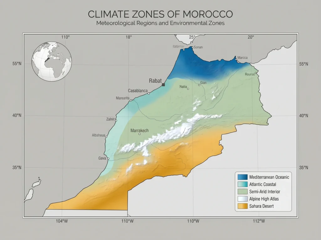
Morocco Climate Map: When to Visit Each Region
Morocco’s climate changes as much as its landscape. The coast stays mild for most of the year, the mountains turn cold and snowy in winter, and the desert swings between pleasant winters and brutal summers. Matching your timing to the region you most want to see makes a real difference to the trip.
| Region | Climate | Best Time to Visit |
|---|---|---|
| Northern Morocco | Mild all year, rainy from October to April, dry summers | April to June, September to October |
| Atlantic Coast | Ocean-cooled, comfortable 18 to 28 degrees most of the year | March to May, September to November |
| Imperial Cities | Hot summers above 38 degrees, mild pleasant winters | March to May, September to November |
| High Atlas Mountains | Cold and snowy December to February, ideal trekking in spring | April to June, September to October |
| Draa-Tafilalet (Tinghir) | Warm days and cool nights, spring is the sweet spot | March to May, October to November |
| Sahara Desert | Extreme heat June to August, comfortable in winter | October to April only |
Morocco Airport Map: Which Airport Should You Fly Into?
Morocco has twelve airports, but most international visitors use only a handful. Choosing the right arrival point can save you a long drive at the very start of your trip. The table below shows the main airports, their codes, and the regions each one serves best.
| Airport | Code | City / Region | Best Used For |
|---|---|---|---|
| Mohammed V International | CMN | Casablanca | National hub, all major airlines, imperial cities |
| Marrakech Menara | RAK | Marrakech | Atlas, desert, Essaouira and Agadir trips |
| Fez-Saiss | FEZ | Fez | Northern imperial cities, Chefchaouen, Merzouga |
| Tangier Ibn Battouta | TNG | Tangier | Northern Morocco and Spain connections |
| Agadir Al Massira | AGA | Agadir | Atlantic south and beach holidays |
| Ouarzazate | OZZ | Ouarzazate | Nearest to Tinghir (70 km) for desert tours |
| Errachidia | ERH | Errachidia | Ziz Valley and eastern desert approach |
| Rabat-Sale | RBA | Rabat | Capital city, limited international routes |
| Nador International | NDR | Nador | Eastern Mediterranean region |
| Dakhla | VIL | Dakhla | Kitesurfing and the far Atlantic south |
Plan Your Trip: AFC Morocco Travel Routes Across the Map
Knowing the map is one thing. Travelling it smoothly is another. We have spent more than thirty years running routes across Morocco from our base in Tinghir, and our tours are built around the very geography you have just read about. The table below shows how our main journeys map onto the country.
Tour | Route Across the Map | Length |
|---|---|---|
Classic Desert Tour | Marrakech, Ait Benhaddou, Dades, Tinghir, Merzouga | 8 to 12 days |
Tinghir and Todra Gorge | Local Draa-Tafilalet focus: gorges, kasbahs, oases | 3 to 5 days |
Morocco Women’s Tour | Full map: Fez, Marrakech, Atlas and the desert | 10 to 14 days |
Imperial Cities Loop | Casablanca, Rabat, Fez, Meknes, Marrakech | 7 to 10 days |
Erg Chigaga Expedition | M’Hamid into the remote western dunes by 4×4 | 4 to 6 days |
Frequently Asked Questions About the Map of Morocco
Where is Morocco on the world map?
Morocco sits in the far northwestern corner of Africa, in the region known as the Maghreb. It is bordered by the Atlantic Ocean to the west, the Mediterranean Sea to the north, Algeria to the east, and Western Sahara to the south. Spain lies just 14 kilometres away across the Strait of Gibraltar, making Morocco the closest African country to Europe.
What are the main travel regions of Morocco?
Morocco has six main travel regions: Northern Morocco with its Mediterranean coast and Rif Mountains; the Atlantic Coast; the Imperial Cities of the centre, the High Atlas Mountains, the Draa-Tafilalet region with its gorges and kasbahs, and the Sahara Desert. Officially the country is split into twelve administrative regions, but these six geographic zones are the practical way to plan a trip.
What is the capital city of Morocco on the map?
The capital of Morocco is Rabat, which sits on the Atlantic coast. This surprises many travellers, who assume the capital is Casablanca. Casablanca is the largest city and the economic centre, but Rabat is the political capital and the seat of government, and it is the city marked as the capital on every official map.
How big is Morocco compared to other countries?
Morocco covers 710,850 square kilometres, which makes it larger than France and slightly bigger than the US state of Texas. It is the largest country in North Africa after Algeria. Despite its size, the variety of landscapes packed into the country means distances feel longer than they look on a map.
What countries border Morocco on the map?
On a map, Morocco shares a land border with Algeria to the east and southeast, and with Western Sahara to the south. Two small Spanish enclaves, Ceuta and Melilla, sit on Morocco’s Mediterranean coast. Across the water to the north, Spain lies only a short ferry ride away from Tangier.
Where is the Sahara Desert on the map of Morocco?
The Sahara Desert lies in the south and southeast of Morocco. The two main dune fields are Erg Chebbi, reached through the town of Merzouga, and Erg Chigaga, reached through M’Hamid. Both sit beyond the Atlas Mountains, and most desert trips begin with a drive south from Marrakech or Fez through the Draa-Tafilalet region.
What are the driving distances between Morocco’s major cities?
Distances vary widely because of the mountains and desert. As a guide, Marrakech to Casablanca is around 240 kilometres or 2.5 hours, Marrakech to Fez is around 550 kilometres or 7 hours, and Marrakech to the Merzouga dunes is around 430 kilometres but takes 8 to 9 hours over mountain roads. Always allow more time than the distance suggests.
What is the highest mountain shown on the Morocco map?
The highest point on the Morocco map is Jebel Toubkal, which rises to 4,167 meters in the High Atlas range south of Marrakech. It is the highest peak in all of North Africa and a popular trekking summit, usually climbed from the village of Imlil over two or three days.